Cartas Náuticas

Busca y consulta tablas náuticas vigentes con facilidad

Cartas Náuticas Vigentes

Plantilla con 114 tablas para buscar cartas náuticas actuales y detalladas.

Muy útil y fácil de usar.

María P.

"

Cartas Tematicas

You didn’t come this far to stop

blue and white striped round textile
an abstract photograph of a curved wall
low-angle photography of blue glass walled building during daytime

Explore our products

Provide a short description of categories listed below.

white concrete building during daytime

ID: 1

PLAN: Continental

IOA:10

TITULO:Cabo Manglares - Punta Malpelo

PROPOSITO:General

ESCALA:600000

EDICION:1era. 2022

Category title

Write a short description of this category

ID: 1

PLAN: Continental

IOA:10

TITULO:Cabo Manglares - Punta Malpelo

PROPOSITO:General

ESCALA:600000

EDICION:1era. 2022

Category title
black blue and yellow textile
a man riding a skateboard down the side of a ramp
white concrete building during daytime

Write a short description of this category

Category title

Write a short description of this category

Category title

Write a short description of this category

Preguntas frecuentes

¿Qué es esta tabla?

Es una tabla con 5 columnas y 114 filas para organizar datos.

¿Para qué sirve?

Sirve para estructurar información de manera clara y ordenada.

¿Cómo puedo usarla?

Puedes llenarla con datos específicos según tus necesidades o proyectos.

¿Es editable la tabla?

Sí, puedes modificarla para adaptarla a tus requerimientos.

¿Puedo imprimirla?

Claro, la tabla está diseñada para facilitar su impresión.

¿Hay algún formato recomendado para usarla?

Se recomienda usar formatos compatibles con hojas de cálculo para mejor manejo.
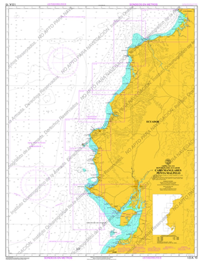
Preguntas frecuentes

¿Qué son las cartas?

Son mapas náuticos que muestran detalles para la navegación segura.

¿Cómo usar el buscador?

Escribe palabras clave en la tabla para encontrar cartas específicas rápido.

¿Qué información incluye cada carta?

Cada carta muestra id, plan, ioa, título, propósito, escala, edición e imagen.

¿Cuántas cartas hay?

Hay un total de 114 tablas disponibles para consulta.

¿Dónde ver imágenes?

Las imágenes están enlazadas en cada carta para visualización rápida.

A detailed nautical chart showing the coastline from Cabo Manglares to Punta Malpelo with clear markings and scale.

Cartas

Navega con seguridad usando nuestras cartas náuticas vigentes.

Close-up of a nautical chart highlighting the scale and edition details from 2022.
A digital search interface showing the table of nautical charts with categories like id, plan, and title.
A printed nautical chart spread out on a wooden table with navigational tools nearby.